Shanthinagar occupies real estate that would make most Bangalore neighbourhoods envious — walking distance to Cubbon Park, a stone’s throw from Lalbagh, and central enough that residents routinely describe it as being “in the heart of the city.” That centrality, more than any single feature, defines what living here actually feels like. Here’s a complete breakdown of where it sits, its pin code, transport options, and what surrounds it.
Shanthinagar Overview
| Detail | Information |
| Locality | Shanthinagar |
| City | Bengaluru |
| State | Karnataka |
| Pin Code | 560027 |
| Assembly Constituency | Shanti Nagar |
| Region | Central Bengaluru, Bangalore South taluk |
| Nearby Metro Stations | Lalbagh (Green Line), Mico Bosch, Langford Town (Purple Line area) |
| Nearest Railway Station | KSR Bengaluru City Junction (approx. 4.7 km) |
| Major Roads | BTS Main Road, Lakshmi Road |
| Bordering Localities | Wilson Garden, Richmond Town, Vivek Nagar, Adugodi |
Location and Character
Shanthinagar sits firmly in Central Bengaluru, one of the city’s older, more established neighbourhoods, and its location does most of the talking. Cubbon Park and Lalbagh, two of Bangalore’s most-loved green spaces, both sit within easy reach, and the locality’s proximity to St. Joseph’s University campus and Mallya Hospital gives it a mixed identity — part student hub, part settled residential pocket, part medical and institutional centre. That density of nearby landmarks, combined with genuinely good day-to-day connectivity, has kept the area consistently popular with students, professionals, and long-settled families alike, even as rental rates on older properties have climbed noticeably in recent years.
Pin Code Details
Shanthinagar’s pin code is 560027, administered under the Shanthinagar post office within the Bangalore South taluk. The code is fairly compact compared to some of Bangalore’s sprawling suburban postal zones, given that Shanthinagar itself is a well-defined, centrally located neighbourhood rather than a collection of scattered sub-localities — though addresses still benefit from a specific road or landmark reference given the density of institutions and residential blocks packed into this stretch of the city.
Getting Around: Metro, Roads, and Rail
Roads
BTS Main Road and Lakshmi Road form the backbone of local road access, though both come with real trade-offs residents mention consistently — heavy evening gridlock along BTS Main Road and severe parking scarcity on Lakshmi Road, driven by the sheer density of vehicle ownership in a centrally located, older neighbourhood. The Richmond Flyover junction nearby adds to noise levels for buildings close to it, a common complaint among long-term residents.
Rail
KSR Bengaluru City Junction, the city’s main railway station, sits roughly 4.7 km away, making it a manageable but not walkable distance for anyone needing to catch a long-distance train. This central positioning is itself a genuine convenience compared to many outer Bangalore suburbs where the main station is a much longer haul.
Metro
Metro access here depends on which direction you’re travelling. Lalbagh Metro Station on the Green Line sits about 3.2 km away, while Mico Bosch, Langford Town, and Kempegowda Majestic stations on the Purple Line network offer alternative routes for residents closer to those corridors. Some residents describe the metro as a bit of a trek at 3-4 km out, meaning many locals still lean on Bengaluru’s dense bus network for daily commuting rather than relying on rail alone.
What’s Nearby: Markets, Malls, and Everyday Essentials
Markets
Being in the heart of the city means daily shopping needs are covered within a short distance, roughly 2 km by most residents’ accounts, without needing to travel to a specific dedicated market district.
Malls
Garuda Mall sits just minutes away, giving residents a proper retail and entertainment option without a long commute — one of the locality’s most consistently praised conveniences.
Everyday Essentials
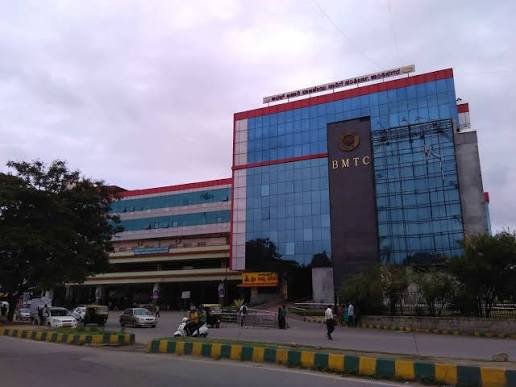
Mallya Hospital anchors healthcare access for the neighbourhood, and the Shanthinagar BMTC Bus Station provides direct connectivity to a large share of the city, plus long-distance government buses reaching as far as Tirupati and parts of Tamil Nadu. For education, St. Michael’s Primary School and Bangalore Institute of Technology sit nearby, alongside St. Joseph’s University, giving the locality a genuine academic presence. Cubbon Park’s walkable proximity adds recreational value that few other centrally located Bangalore neighbourhoods can match, though residents do note a notable shortage of dedicated children’s playgrounds within the locality itself.
Frequently Asked Questions
Q1. Is Shanthinagar within walking distance of a metro station?
Not quite. The nearest stations — Lalbagh on the Green Line and Mico Bosch or Langford Town on the Purple Line network — sit roughly 3-4 km out, so most residents rely on autos, buses, or their own vehicle for the last stretch to a station rather than walking.
Q2. How bad is the parking situation, realistically?
It’s a genuine, frequently mentioned constraint, particularly along Lakshmi Road, where street parking is scarce given how many residents own cars. The Shanthinagar bus stand does offer paid parking as an alternative for anyone struggling to find space near their building.
Q3. Is Shanthinagar a good fit for families with young children?
It works well for access to schools, healthcare, and green spaces like Cubbon Park, but residents do flag a shortage of dedicated playgrounds within the locality itself, so families prioritising outdoor play space for kids may want to factor that in.
Q4. Why do property or rental rates in Shanthinagar seem to be rising faster than nearby areas?
The combination of central location, strong institutional presence, and consistently high demand from students and professionals has pushed rental premiums up, particularly on older properties, faster than in some more peripheral Bangalore neighbourhoods with newer housing stock.