A 14th-century medieval bridge called the Satpula sits quietly at the edge of Malviya Nagar, built by Mohammad bin Tughlaq centuries before the locality around it took shape. That kind of layered history — old Delhi heritage sitting beside malls and metro stations — is exactly what makes this South Delhi neighbourhood stand out. Here’s a full breakdown of where it sits, its pin code, transport options, and what surrounds it.
Malviya Nagar Overview
| Detail | Information |
| Locality | Malviya Nagar |
| City | Delhi |
| District | South Delhi |
| Pin Code | 110017 |
| Named After | Madan Mohan Malviya |
| Developed | 1950s, on land formerly part of Shahpur Jat village |
| Nearest Metro Station | Malviya Nagar (Yellow Line) |
| Nearest Railway Station | Hazrat Nizamuddin (approx. 11.8 km) |
| Major Road | Sri Aurobindo Marg |
| Bordering Localities | Saket, Hauz Khas, Panchsheel Park, Sheikh Sarai, Sarvapriya Vihar |
Location and Character
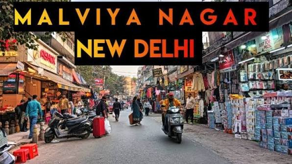
Malviya Nagar sits between Saket and Hauz Khas in South Delhi, developed in the 1950s to house refugees from Pakistan, including Punjabi, Sindhi, and Rajasthani families, with a later wave of Afghan refugees arriving after the Soviet-Afghan war. That layered migration history still shows in the neighbourhood’s culinary and cultural mix today. The colony folds in several well-known sub-pockets, including Shivalik Colony, Geetanjali Enclave, Begumpur, Sarvodaya Enclave, and Adchini, all stretching along Sri Aurobindo Marg, one of South Delhi’s most important arterial roads. Geographically, the area is gently undulating, with leafy residential streets giving way to busier commercial lanes closer to the main market.
Pin Code Details
Malviya Nagar’s pin code is 110017, covering the bulk of its sub-localities under the New Delhi South postal division. Given how many enclaves — Shivalik Colony, MMTC Colony, Navjeevan Vihar, and others — share this single code, it’s worth specifying the exact block or colony name on any address, since 110017 spans a genuinely large stretch of South Delhi rather than a single compact neighbourhood.
Getting Around: Metro, Roads, and Rail
Roads
Sri Aurobindo Marg runs through Malviya Nagar as its principal artery, connecting directly to the Outer Ring Road and giving residents quick access to Saket, Hauz Khas, and beyond. Internal streets are generally wide in the residential stretches, though narrower commercial lanes near the main market see regular congestion, especially during peak shopping hours.
Rail
Hazrat Nizamuddin is the nearest railway station, roughly 11.8 km away, serving both long-distance and suburban routes. There’s no station within the locality itself, so most residents rely on road transport to reach it, typically a 30-40 minute drive depending on traffic.
Metro
Malviya Nagar Metro Station on the Yellow Line has served the locality since September 2010, offering direct trains toward Millennium City Centre Gurugram in one direction and Samaypur Badli in the other. Several nearby stations — Hauz Khas, Chirag Dilli, and Panchsheel Park — add further access points within a short distance, giving residents genuine flexibility depending on which part of the sprawling locality they live in. The metro station’s underground structure and dedicated parking make it a reliable daily option rather than a fair-weather convenience.
What’s Nearby: Markets, Malls, and Everyday Essentials
Markets
Malviya Nagar Main Market handles daily shopping needs, from groceries to clothing, and stays busy through most of the week. The area’s dining scene runs unusually diverse for a residential South Delhi colony, with cafés and restaurants serving both local and international cuisines, a reflection of the neighbourhood’s mixed migrant history.
Malls
Select Citywalk in nearby Saket is the standout option, offering a full mall experience with a multiplex, food court, and premium retail brands. DLF Avenue adds a second nearby choice for residents who want more variety without travelling far.
Everyday Essentials
Max Super Speciality Hospital anchors the locality’s healthcare access, backed by several smaller clinics scattered through the residential blocks. Sri Aurobindo College serves as a notable higher-education institution within the neighbourhood, and green spaces like Siri Fort Park and Vijay Mandal Park give residents recreational options that many comparably dense South Delhi colonies lack.
Frequently Asked Questions
Q1. Is Malviya Nagar considered a safe, family-friendly locality?
Yes, residents consistently rate it well for both connectivity and safety, and its mix of parks, schools, and hospitals makes it a practical choice for families, though narrower internal lanes near the market do get congested during peak hours.
Q2. How far is Malviya Nagar from Indira Gandhi International Airport?
Roughly 12–13 km, typically a 30-40 minute drive depending on traffic and the route taken through the Outer Ring Road or Sri Aurobindo Marg.
Q3. Which metro station should I use if I live on the Hauz Khas side of Malviya Nagar?
Depending on the exact block, Hauz Khas or Panchsheel Park metro stations might actually be closer than Malviya Nagar’s own station, so it’s worth checking distances from your specific street rather than assuming the named station is automatically nearest.
Q4. What kind of housing is typical in Malviya Nagar, and how do prices vary?
The locality has a broad property range, from older independent houses in enclaves like Shivalik Colony to newer builder floors and premium apartments, with rates spanning roughly Rs. 4,500 to Rs. 15,500 per square foot depending on the specific pocket and proximity to the metro or main market.